After 10+ years in this space, the Wide World of SPoRT blog is moving to a new platform. Our content will remain the same but just moving to a new address! Please continue to follow us at: https://weather.msfc.nasa.gov/sport/blog/.
SPoRT-LIS Soil Moisture Percentile Reveals Difficulty Forecasting Hurricane Sally
By Ben Houser and Jonathan Case
In early September, Hurricane Sally was the 18th named storm of the very active 2020 Atlantic hurricane season. Forming over the Bahamas, the storm was designated a tropical depression on 12 September and continued to grow, reaching hurricane status on 14 September. At 9:45 UTC on 16 September, Sally made landfall near Gulf Shores, AL, with sustained winds of 105 miles per hour. The storm’s landfall resulted in power loss to over 500,000 homes and businesses in Alabama, Georgia, Mississippi, and Florida . Hurricane Sally ultimately caused an estimated $5 billion of damage and eight confirmed fatalities, adding to the heavy human cost of this year’s hurricane season.
In the days leading up to its landfall, Sally’s track was unclear to forecasters. An extended region of low pressure called a trough to the storm’s northeast made it difficult for models to forecast where the hurricane was heading. Due to the hurricane’s unclear path, the National Hurricane Center (NHC) issued hurricane and tropical storm warnings along much of the Gulf Coast, reaching as far west as New Orleans, and many areas along the Gulf Coast were evacuated. Soil moisture percentile imagery generated by SPoRT’s real-time Land Information System (LIS) reveal this uncertain forecast, as there was a distinct southeastward shift in the axis of high soil moisture percentiles over three, two, and one day forecasts, all valid for 18 September as Sally approached and made landfall along Alabama’s southern coast (Fig 1).

To model soil moisture percentile, rainfall forecasts from the Global Forecast System (GFS) model were input to the SPoRT-LIS. The GFS is a forecast model produced by NOAA’s National Centers for Environmental Prediction (NCEP) Environmental Modeling Center (EMC). The GFS depiction of Sally was initially too far to the northwest in the 3-day forecast, and therefore its predicted rainfall resulted in higher soil moisture percentiles that were also too far to the northwest (first image of Fig. 1 animation). The GFS forecast for the zone of heavy rain became more accurate as the storm approached landfall, with the one-day forecast soil moisture percentiles showing the southeastward shift in the forecast, more closely aligned to the observed rainfall on 17 September across southeastern Alabama into western and central Georgia (Fig. 2). Such examples demonstrate the difficulty in predicting accurate precipitation forecasts, even in the short-term, as many meteorological factors can combine across various spatial scales to produce such an event.

Current Activities in SPoRT’s Tropical Research Focus Area
By Ben Houser
So far, the 2020 Atlantic hurricane season has been unusually active with fifteen named storms, five of which have reached hurricane strength. Typically, an average hurricane season will produce twelve named storms between June and November; 2020’s season has surpassed this average before the season’s half-way point. At the beginning of August, NOAA predicted an “extremely active” season was possible. Tropical cyclones are one of SPoRT’s most prominent research focuses, and SPoRT scientists are leveraging satellite remote sensing instruments such as the GOES-R Series Geostationary Lightning Mapper (GLM), the Global Precipitation Measurement (GPM) Mission’s GPM Microwave Imager, and the JPSS Series Cross-track Infrared Sounder (CrIs) and Advanced Technology Microwave Sounder (ATMS) to make new and unique observations about the tropical cyclone environment and behavior. SPoRT researchers focus on the diurnal cycle of tropical cyclones, the behavior of lightning in tropical cyclones, and the behavior and structure of cyclones’ powerful winds. These observations are being applied to improve operational models and forecasting tools, minimizing the risk that tropical cyclones pose to life and property. SPoRT is also preparing for the launch of The NASA Time-Resolved Observations of Precipitation structure and storm Intensity with a Constellation of Smallsats (TROPICS) mission, which will provide observations of the tropics with groundbreaking observational frequency.
Tropical cyclones exhibit a distinct diurnal cycle. In other words, tropical cyclones go through predictable changes every day, in which the storm structure is affected by the day / night cycle of solar radiation. However, according to SPoRT tropical cyclone researcher Dr. Erika Duran, the exact mechanisms of these changes are still unknown. “Given the impacts on storm structure, this phenomenon is important for both forecasters and researchers to understand. Especially when such changes may occur close to a tropical cyclone landfall, there is potential for the improvement of wind and rainfall forecasts as more about this cycle is understood,” said Dr. E. Duran. A scientific understanding of the tropical cyclone diurnal cycle has the potential for improved forecasts and emergency response, so SPoRT is leveraging its expertise with satellite observations to explore this phenomenon. “SPoRT is currently using a number of satellite missions and instruments to observe and analyze the diurnal cycle of tropical cyclones. For example, precipitation data from the GPM IMERG product are currently being used to estimate the diurnal cycle of rainfall in Hurricane Dorian (2019). Lightning data from GLM on GOES-E is also being used to analyze the diurnal cycle in Hurricane Dorian,” said Dr. E. Duran. Dr. E. Duran is also exploring the possibility of using NUCAPS satellite sounding retrievals to track the tropical cyclone diurnal cycle. Research into the diurnal cycle will be bolstered by the launch of the TROPICS mission in 2022, which will make it possible to observe tropical cyclone storm structure in great detail over the storm’s entire lifecycle.
The patterns and behavior of the wind produced by a tropical cyclone is called its wind field, and, according to SPoRT tropical researcher Dr. Patrick Duran, is an important element of forecasting tropical cyclone’s impact. “The size and structure of a tropical cyclone’s wind field has important implications for storm surge, wave height, and how destructive the storm’s winds will be at landfall. Operational models do not always accurately predict the size of a tropical cyclone’s wind field, however,” Dr. P. Duran said. “Storms with larger wind fields can do more widespread wind damage at landfall because damaging winds extend over a larger area.” These wind fields are difficult to predict because they are influenced by several internal and external factors. The storm interacts with the atmosphere and climate around it; these interactions can impact the wind field but are difficult to forecast with great detail. Events within the storm can also impact the wind field but are similarly hard to anticipate. Despite these difficulties, satellite observations are powering SPoRT’s efforts to understand and track wind fields. According to Dr. P. Duran, “satellite platforms like the Soil-Moisture Active-Passive (SMAP) instrument and the Cyclone Global Navigation Satellite System (CYGNSS) constellation measure wind speed by detecting how rough the ocean surface is. SPoRT combines these observations with other similar instruments operated by EUMETSAT that can show how a hurricane’s winds evolve with time.” SPoRT also uses satellite observations to relate tropical cyclone wind fields to the processes taking place within the storms. So far, SPoRT scientists have shown that a storm’s wind field can expand and contract throughout the day, indicating a diurnal cycle. This cycle is able to be tracked using widely accessible GOES imagery, and so forecasters may be able to track diurnal wind field changes without access to wind speed data, resulting in improved forecasts.

SPoRT is also exploring the role of lightning in tropical storm intensification, leveraging the state-of-the-art observational capacity of the GOES-R Series GLM. Lightning, depending on where in the storm it occurs, can be a key signal of storm intensification. SPoRT lightning scientist Dr. Chris Schultz says, “the key is where the lightning is located in the system. Stevenson et al. (2018) indicated that 92% of lighting increases within the radius of maximum wind resulted in an intensity change or maintenance. When lightning is located in the outer rainbands, tropical cyclone weakening was generally observed.” SPoRT is currently working to integrate GLM observations into the scientific understanding of tropical cyclones, which will improve forecasters’ ability to anticipate changes in storm intensity. “This involves a partnership with fellow scientists Dr. Stephanie Stevenson and Dr. Jason Dunion at NOAA’s National Hurricane Center and Hurricane Research Division,” said Dr. Schultz. “Early results indicate that the size and energy of the lightning within the eyewall can indicate the type of intensification or maintenance that is ongoing within the system.”
SPoRT scientists are preparing for the launch of the TROPICS mission in 2022, which will provide groundbreaking observations of tropical cyclone precipitation structure and thermodynamics. The satellite constellation will improve researchers’ ability to understand and monitor tropical cyclone structure throughout the storm lifecycle, and will provide more detailed observations at an extremely high observational frequency. Currently, much of SPoRT’s research into tropical cyclones is based on hyperspectral infrared sounders. However, according to SPoRT scientist Dr. Emily Berndt, these types of observations can fail when skies are cloudy. “TROPICS offers the opportunity to look at these same types of events offering all-sky observations, and the ability to diagnose dry air intrusions closer to the storm center and at higher temporal resolution than infrared sounders onboard polar-orbiting satellites,” said Dr. Berndt. TROPICS could also be helpful in uncovering the tropical cyclone diurnal cycle, as its observations will provide more details into the thermodynamic processes of tropical cyclones in comparison to current observers. Dr. Berndt is also the TROPICS Deputy Program Applications Lead and is responsible for engaging the atmospheric science community through the TROPICS Early Adopter program. The Deputy Program Applications role represents a collaboration between SPoRT and NASA Applied Sciences, and is crucial both for realizing the cross-benefit of science and applications and increasing the practical societal benefit of NASA missions. “This entails hosting quarterly telecons to foster interaction between the community of end users and the science team and making data and information available to the community to inform them about TROPICS,” said Dr. Berndt. As part of this collaboration, SPoRT has made the mission’s official proxy data available to the public, so that end-users can test mission-formatted data and ensure that their operations are ready for the launch.

Tropical cyclones are one of the most severe weather events that occur every year, and are responsible for extreme damage all over the world. While much about tropical cyclones is still unknown, SPoRT is applying its expertise in transitioning research to operations to improve the scientific understanding of these storms. SPoRT’s findings lead to improvements to forecasting tools and models, allowing forecasters to anticipate storms with more time and more accuracy. Ultimately, better forecasting leads to better emergency response, minimizing the damage of tropical cyclones and saving lives.
References
Stevenson, S. N., K. L. Corbosiero, M. DeMaria, and J. L. Vigh, 2018: A 10-Year Survey of Tropical Cyclone Inner-Core Lightning Bursts and Their Relationship to Intensity Change. Wea. Forecasting, 33, 23–36, https://doi.org/10.1175/WAF-D-17-0096.1.
Nolan, D. S., Atlas, R., Bhatia, K. T., and Bucci, L. R. (2013), Development and validation of a hurricane nature run using the joint OSSE nature run and the WRF model, J. Adv. Model. Earth Syst., 5, 382– 405, doi:10.1002/jame.20031.
Exploring Daily Changes in Tropical Cyclone Temperature and Moisture using NUCAPS Satellite Soundings
Written by Erika Duran
Each year, tropical cyclones (i.e., hurricanes, typhoons) develop year-round across the globe, creating potential threats to humanity from extreme winds, rain, and storm surge. Although great strides have been made in both the forecasts of tropical cyclone (TC) track and intensity over the last several decades, predicting short-term (~24-hour) structure and intensity change remains a significant forecast challenge. As part of the tropical meteorology focus area at the NASA SPoRT Center, SPoRT researchers continue to investigate new ways to leverage NASA datasets to improve TC forecasts, both developing products that aid forecasters in their analyses as well as preparing forecasters and other end-users for the next generation of NASA satellites.
One of current projects in the tropical research focus area at NASA SPoRT is exploring the usefulness of applying NOAA Unique Combined Atmospheric Processing System (NUCAPS) satellite soundings to diagnose daily changes in TC thermodynamic structure. The NUCAPS algorithm retrieves vertical profiles of temperature, humidity, trace gases, and cloud properties through a combination of both infrared and microwave instrumentation. NUCAPS soundings are operational on both the Suomi-National Polar-orbiting partnership (S-NPP) and NOAA-20 satellites, as well as the Meteorological Operational (MetOp) A/B satellites. NUCAPS soundings have demonstrated significant value in several applications, including diagnosing the pre-convective environment, locating stratospheric intrusions, identifying the Saharan Air Layer (SAL), and diagnosing cold air aloft. However, these soundings could also be unique assets in observing the tropical environment, particularly the TC environment, as they observe a larger portion of the environment than a single radiosonde launch or dropsonde from reconnaissance aircraft (Fig 1), and fill gaps in times when radiosondes or aircraft reconnaissance are not available.

Using a combination of overpasses from S-NPP, NOAA-20, and MetOp A/B, several snapshots of the diurnal cycle over a single storm can be captured using NUCAPS soundings. Such combinations of swaths may be useful in assessing short-term (< 24 hr) thermodynamic changes in a TC. Currently, researchers at SPoRT are exploring viewing NUCAPS soundings in a storm-relative framework, which categorizes each sounding based on the radial distance from the TC center as opposed to its latitude and longitude position. Due to the circular symmetry of the TC circulation, and the preference for certain TC structures such as the eyewall, spiral rainbands, and external convection to exists within certain radial distances from the storm center, this framework allows one to easily assess how the thermodynamic environment around and near these features may change at any given time.
Figure 2 shows an example of temperature anomaly profiles in both the morning and the afternoon for Tropical Storm (TS) Fay on 8 July, 2020. These profiles are composites of all NUCAPS soundings that fell within a radial distance of 100-200km, 200-300km, and 300-400km from Fay’s center, where the mean profile over the course of the day for that radial distance has been removed to yield the anomaly profile. Comparing the morning profile (00-03 local time, or LT) to the afternoon profile (12-15 LT), a clear diurnal cycle is evident in both the temperature and moisture soundings (Duran et. al 2020). Nearly equal and opposite changes are observed throughout the depth of the troposphere, demonstrating the effect that radiation has on the TC environment.

TC radial anomalies can also be plotted as plan-view images instead of vertical profiles. Doing so allows one to easily identify regions of moist/dry air, as well as gradients in temperature and moisture (Fig 3). Averaging from 700-400mb and 12-15 LT for TS Fay on 8 July, 2020, dark brown colors show a significant amount of dry air north of the storm, while lighter brown colors show drier air potentially penetrating near the core of the TC circulation. Comparing this to the GOES low-level water vapor imagery at 00 UTC on 9 July, 2020 shows that the dry air indicated in the radial anomalies lines up well with lower levels of water vapor from GOES. One benefit, however, of NUCAPS radial anomalies in this context is that one can identify and quantify the amount and location of dry air vertically in the atmosphere.

These experimental products show promise in using NUCAPS soundings to help diagnose short-term changes in TC thermodynamic structure, and researchers at SPoRT, along with collaborators at the Science and Technology Corporation (STC) and the Joint Polar Satellite System (JPSS), continue to assess their utility throughout the 2020 Atlantic hurricane season. Real-time products are available online, and more information about radial anomalies is given here.
References
Duran, E. L., E. B. Berndt, and P. Duran (2020): Observation of the Tropical Cyclone Diurnal Cycle Using NUCAPS Satellite Soundings. Mon. Wea. Rev., in prep.

SPoRT Provides Forecasts of Hurricane Isaias’ Landfall to NOAA’s Hurricane Research Division
Written by Patrick Duran
Each year, the Hurricane Research Division (HRD) of the National Oceanic and Atmospheric Administration (NOAA) conducts a field campaign to provide real-time observations to forecasters at the National Hurricane Center. The field program’s three aircraft collect data that are invaluable in improving the accuracy of hurricane forecasts. An important part of this field campaign is a daily weather briefing led by scientists from HRD, other federal agencies, and universities. This briefing is used to make important decisions regarding aircraft deployment and flight patterns.
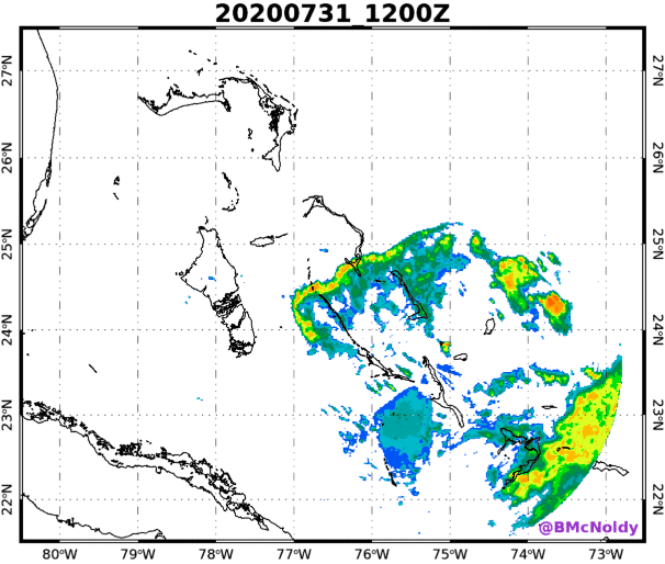
SPoRT scientists led HRD’s daily weather briefings for the week of August 3-7. The briefings consisted of real-time analysis of satellite and aircraft datasets along with an interpretation of model forecasts. The beginning of the week included analyses and forecasts for Hurricane Isaias as it was off the east coast of Florida. While Isaias moved through the warm waters of the Bahamas on the weekend of July 31 to August 2, an eye formed once for a brief time, but decayed after only a few hours (Fig. 1). Over the next two days, Isaias’ eyewall exhibited multiple cycles of eyewall convective intensification and, at times, appeared to be close to closing off an eye once again. But each time, the eyewall convection on the southwest and southern side of the eyewall failed to persist.

This failure to organize was primarily caused by the presence of southwesterly vertical wind shear, which favors the formation of convection in the northeastern semicircle of the storm (“downshear” of the storm center) but suppresses convection in the southwestern semicircle (“upshear” of the storm center.)
Another factor that helped to prevent Isaias’ intensification over the warm waters of the Gulf Stream was very dry air in the mid-levels of the atmosphere. This dry air was well-observed by SPoRT’s Gridded NUCAPS product, which depicted relative humidity values below 20% over a broad area to the west and southwest of Isaias (Fig 2). The presence of dry air “upshear” of a tropical cyclone normally indicates that the environmental flow is acting to move the dry air into the storm, which further inhibits its ability to intensify.

The combination of vertical wind shear and dry air not only inhibited the storm’s intensification, but also reduced the storm’s impact on Florida by suppressing convection on the western side of the storm. Although Isaias’ center passed close to Florida’s east coast, relatively little rainfall fell on the peninsula because of this effect (Fig 3).

Finally, an interesting phenomenon observed in Isaias was a number of convective bands that propagated far from the storm as it moved through the Bahamas. Some of these bands can be seen on July 31 and August 1 in the first radar loop above, moving far northwest of the storm center. They also can be seen impacting Florida on August 1 and 2 (Fig 4).

SPoRT scientists hypothesize that these bands could be similar to midlatitude squall lines that propagate along pools of cool, dense air near the surface. The dry air observed by NUCAPS to the west of the storm could have helped to maintain these cold pools, allowing the lines of thunderstorms to propagate far from the storm and affect Florida while the storm was still far offshore. SPoRT plans to investigate this further using satellite and surface-based observations combined with idealized modeling. Gridded NUCAPS was a highly valuable tool during the HRD map discussions, helping to characterize the dry air that prevented the storm’s intensification. It also shows promise in helping to diagnose structural changes like the development of squall lines on the periphery of a hurricane.
My Experience as a NASA SPoRT Intern
By Ben Houser
As the summer comes to an end, interns across NASA are preparing to send a final Microsoft Teams message of farewell, before shutting down their laptops for the last time. My summer internship at NASA SPoRT, where I work as a writer and programmer, is also coming to an end. A little bit about me: I am an undergrad at UAH, working towards a dual degree in English and computer science. I write many of the articles that appear on the SPoRT Blog. Being able to apply both of my majors has been a fantastic opportunity, and I feel lucky to be excited about what I do every day.
Part of the reason for this excitement is that most of the stuff SPoRT does is, to me, really cool; even without an atmospheric science background, I find the imaging satellites, scientists, and projects I cover on the SPoRT blog to be incredibly interesting. I covered the SWOT satellite, which is going to be the first ever satellite to survey water level around the world when it launches. This observational capability is going to be huge for many commercial and research interests, allowing scientists to track water anywhere on the planet (except the poles). I talked to SPoRT scientist Dr. Aaron Naeger about the TEMPO satellite, launching in 2022, which will make hourly observations of air-pollution over North America. This is a big deal for air quality researchers like Dr. Naeger, as TEMPO will be a major step up from current air-pollution tracking satellites. Writing a blog post involves doing research, talking to scientists, drafting, and making revisions, and so I spend a lot of time with individual topics. I hope the result is an engaging article that makes SPoRT’s work interesting to a wide audience. Since I began working at SPoRT, I’ve written a number of blog posts, and I think that the quality of my writing has improved since I began.

Before working at SPoRT, I had never thought about where the weather forecast comes from; now, I cover the flow of atmospheric science from researcher to forecaster. I’ve had the opportunity to sit down with several SPoRT scientists, and I am always excited to get insight into what scientists are doing to improve the capabilities of local forecasters. Being a small part of the SPoRT team has been my favorite part of the internship, and I’ve appreciated the chance to see how a NASA project works, how scientists do their jobs, and how their work impacts the real world.
My job at SPoRT has been my first experience coding on a professional level. This involves writing web pages, attending developer meetings, and writing extensive Python programs, all of which was new to me. Over the course of the summer, I authored a number of webpages. I had to start from scratch, learning the basics of web development and studying pages that had already been written. It turns out that web development is something I enjoy. Writing software in Python was also a learning experience, as I crawled through documentation and tutorials to get my bearings. The practical experience I’ve gained as a programmer at SPoRT is invaluable, and has neatly supplemented the courses I’ve taken at UAH; I feel more confident both as a programmer and a computer science student after my experience at SPoRT.
My summer internship at SPoRT has been so enriching, as I’ve gained professional experience both writing and coding. This experience not only helped to prepare me for the rest of my career, but also gave me a perspective on working for the Agency and the research to operations process. SPoRT has exposed me to the world of research, and I am grateful for the opportunity to work with scientists. The enrichment opportunities provided by the Internship program were also incredible; hearing from professionals about their careers and experiences at NASA gave me a look into other parts of the Agency and illuminated career paths that I didn’t know existed. As I continue to work for SPoRT into the fall, I am looking forward to the road ahead.
Promising Test Results for SPoRT Machine Learning Stream Height Model
By Ben Houser
Currently, forecasters who try to predict the risk of flooding have a limited toolbox to work with. Forecasters at National Weather Service Weather Forecast Offices (WFOs) generally rely on NOAA’s River Forecast Centers (RFCs) for stream height forecasts. However, when RFCs produce stream height forecasts, forecasted precipitation is typically accounted for the first one or two days of the forecast. This means that if a flooding event is more than two days out, the forecast will not pick it up. To solve this problem, SPoRT is using machine learning to develop a powerful new stream height product that will produce five day forecasts based on precipitation, soil moisture, and observed stream height data.
The machine learning project, led by Dr. Andrew White of UAH and SPoRT and Kris White of NOAA and SPoRT, is one of the first of its kind in the stream height forecasting field. The SPoRT product produces similar graphics to RFC forecasts, displaying the stream height prediction as well as precipitation forecasts (Fig 1). The machine learning model’s graphics are easy to understand, and can be used by forecasters in a wide range of applications.

In order to produce accurate predictions five days in advance, SPoRT’s machine learning product combines data and forecasts of rainfall, observed stream height, and soil moisture from the SPoRT-LIS product. The machine learning is powered by a Long Short-term Memory (LSTM) network, which is fed historical data on rainfall, observed stream height, and soil moisture and then determines how useful each dataset is to predict future stream height. After this training dataset is analyzed, the LSTM network will understand how soil moisture, observed stream height, and precipitation values impact future stream heights. The network can now make accurate predictions of future stream height from current observed soil moisture and stream height values and forecasted precipitation. The model’s accuracy is largely dependent on the accuracy of precipitation forecasts, so poor precipitation forecasts can lead to poor stream height forecasts. In this application, LSTM networks are especially powerful because they are capable of learning both the long-term and short-term importance of data. Since forecasters desire long term flooding predictions, especially when heavy rainfall is forecasted confidently, the LSTM network’s ability to weigh data based on its importance over longer periods of time is especially useful.
In order to test the effectiveness of the new machine learning forecasting method, SPoRT has partnered with a number of National Weather Service offices and the Lower Mississippi River Forecast Center. Testing partners were given information on the project’s background, and, from 1 February to 30 April 2020, were given access to training and forecasts from the LSTM stream height model. At the Flint River in Brownsboro, AL, the LSTM forecast did well (Fig 2). The forecasts’s probability of detection for predicted periods of twelve hours or less was fairly high, and the LSTM forecasts showed improvement over the River Forecast Center’s forecasts in many cases. Despite lower probability of detection towards the end of the testing period, surveys taken by testing partners suggest that situation awareness and flood warning lead time improved. The LSTM’s accuracy value was also high, but this is partly due to the relatively low amount of flooding that occurred during the testing period. The accuracy value represents the total amount of correct predictions divided by the total number of predictions; predictions of no flooding are included, so accurately predicting little flooding can result in a high accuracy value.

Other test sites also exhibited promising results. LSTM forecasts of Big Wills Creek in Fort Payne, AL, exhibited a root-mean-square error of under one foot up to 84 forecast hours (Fig 3). At five days, the root-mean-square error was only about 1.2 feet. A small error value is good, and indicates that the model’s forecasts were close to the observed values.

Forecasts of Big Wills Creek stream height are not provided by an RFC, so the LSTM model is especially useful. According to testing partner feedback, feeding historical data through a machine learning model will be much quicker and simpler than configuring and calibrating a hydrological model for a new gauge. The machine learning model can be used on any river or stream with a gauged basin, allowing for the production of stream height forecasts that RFCs may not provide. In fact, the Arkansas-Red Basin RFC has recently requested machine learning forecasts for streams in their region, which will be included in later rounds of testing and evaluation. Along with the improved forecasts over longer periods, simplicity and usability make SPoRT’s LSTM model uniquely powerful.
So far, the model has proved itself effective, and its increased forecast time makes it potentially lifesaving in dangerous flooding situations. Early testing indicates that the LSTM product can provide forecasters and officials a longer period to prepare for dangerous floods, which could help minimize the damage from severe flooding.
TEMPO: Next-generation pollution tracking instrument offers new solutions to old problems
Written by Ben Houser
When launched in 2022, the Tropospheric Emissions: Monitoring of Pollution (TEMPO) instrument will revolutionize the way scientists observe air pollution and atmospheric chemistry. Hovering 22,000 miles above the equator in geostationary orbit, TEMPO will measure air pollutants over North America every daylight hour; these hourly measurements set TEMPO apart from current air pollution satellites, which are limited in both observation frequency and spatial resolution. TEMPO’s high-resolution hourly measurements will support an array of potential applications, some of which were impossible before TEMPO. For example, public health studies examining the impact of air pollution on health will be possible on shorter timescales than ever before and short-term emissions tracking will give scientists new insight into air pollution.
The TEMPO instrument is a grating spectrometer, which sweeps a mirror over North America and collects both ultraviolet and visible light that has been scattered by particles in the atmosphere. Based on these measurements, the TEMPO Science Team, led by Principal Investigator Dr. Kelly Chance at the Smithsonian Astrophysical Observatory, are developing science algorithms to extract key information on trace gases, aerosols, and clouds present in the atmosphere. At the center of the field of regard, TEMPO’s spatial resolution of 2.1 kilometers per pixel in the north-south direction and 4.5 kilometers per pixel in the east-west direction. Such high resolution allows TEMPO to monitor pollution at sub-urban scales, tracking air quality within the borders of urban areas and surrounding suburbs.
SPoRT scientist Dr. Aaron Naeger is the TEMPO mission Deputy Program Applications Lead, who is responsible for engaging potential TEMPO end-users, coordinating the pre-launch activities of TEMPO end-users, and leading the TEMPO Early Adopter team. Dr. Naeger does extensive research on air pollution and aerosols, and anticipates the impact that TEMPO will have on his work. “Currently I use low-earth orbit satellite data from the NASA Ozone Monitoring Instrument (OMI) and European Space Agency’s (ESA) Tropospheric Monitoring Instrument (TROPOMI) to track and study air pollution across the globe, which are limited to one or two observations per day over the same area,” Dr. Naeger said. “TEMPO will significantly expand the breadth of my research activities by providing hourly observations of air pollutants from morning to evening across Greater North America.” TEMPO’s capabilities will offer new opportunities to scientists like Dr. Naeger, who are currently unable to track air pollution with such high observation frequency. “These new research activities can include studying the complex chemical evolution of pollutant events throughout the day, source contributions from natural and anthropogenic emissions, and impact of different air pollutants on human health,” said Dr. Naeger.
As TEMPO end-users await the instrument’s launch in 2022, the TEMPO early adopter program is helping to ensure that their operations and systems are ready for the new data. The program began in 2019 to provide a means of communication between the TEMPO Science Team and end-users, and to ensure end-users are ready to go when the satellite hosting TEMPO reaches orbit (Figures 1 and 2). To accomplish this, NASA SPoRT is distributing several synthetic TEMPO products, including ozone, nitrogen dioxide, sulfur dioxide, formaldehyde, water vapor, and aerosols. These synthetic products mimic future TEMPO data, allowing end-users to configure and troubleshoot their systems pre-launch. On 18-19 May 2020, a joint virtual Early Adopter workshop was held for TEMPO and MAIA, a second air quality instrument launching in 2022. Dr. Naeger led the TEMPO workshop, which included several presentations on TEMPO’s status, applications, and synthetic data.

Due to TEMPO’s frequent and detailed observations of several air pollutants, there is a wide range of potential applications. One such application is the study of thunderstorms; Dr. Naeger said, “there are a lot of interesting applications but perhaps the most interesting application is focused on the use of nitrogen dioxide observations from TEMPO to monitor and track lightning-produced nitrous oxide in the upper troposphere which can lead to substantial ozone production.” TEMPO may also help researchers understand the relationship between aerosols and tropical cyclones; combining data from TEMPO and other weather tracking satellites will enable researchers to understand how different trace gas and aerosol environments influence the intensity and behavior of tropical cyclones. Researchers plan to use TEMPO for numerous other applications, such as understanding the complex chemistry of smoke plumes from fires, tracking variations in nitrogen oxide emissions from soils in agricultural areas, and monitoring the daily evolution of pollution in areas of complex terrain.

TEMPO’s capability for detailed air quality measurements makes it especially interesting to public health researchers, who study the impact of air quality on human health. “Air quality and epidemiology research studies will be significantly improved through incorporation of TEMPO data,” said Dr. Naeger. “We will be able to understand how different air pollutants impact health by analyzing the hourly TEMPO trace gas products along with health data and records.” Using TEMPO data in air quality models will also lead to more realistic forecasts, and there is a plan to combine TEMPO data with models to improve Environmental Protection Agency’s air quality indices.
In the future, TEMPO will be an important tool in advancing climate change research. “TEMPO can help researchers understand the impact of climate change on air pollution due to wildfires since the hourly observations will effectively monitor the evolution of smoke throughout the day,” said Dr. Naeger. “The longer the TEMPO mission lifetime, the more impact the unprecedented observations will have on climate change research.” A long lifespan means that TEMPO will be able to track changes in the atmosphere over long periods of time, which will reveal even more insight into the role of climate change on air pollution. TEMPO’s climate change research capabilities will be assisted by other satellites around the word: Geostationary Environment Monitoring Spectrometer (GEMS), a similar instrument to TEMPO, was launched over Asia in February 2020. By 2023, a similar air-pollution tracking satellite will also be operational in Europe. This geostationary trio will monitor air pollution and atmospheric chemistry on a global scale. “Utilizing this suite of geostationary observations will be key for global climate change research,” said Dr. Naeger.
SPoRT SST Composite Picks Up Unusual Summertime Tehuano Gap Wind Event
Written by Ben Houser
On 11 June 2020, the National Hurricane Center’s Tropical Analysis and Forecast Branch (TAFB) announced that they were monitoring a Tehuano gap wind event, and issued a Gale warning for the area. On 12 June, the gale force winds continued, and the TAFB forecasted that the strong gap winds would continue into the next week. Typically, Tehuano gap wind events are most common in the winter, with most events occurring between November and March; a gap wind event in June is unusual.
The Isthmus of Tehuantepec is in southern Mexico, bordered by the Gulf of Mexico to the north and the Pacific Ocean to the south. Due to the geography of the Sierra Madre mountain range and the Chivela Pass, a strong gap wind, known as the Tehuano or Tehuantepecer, is periodically forced southward over the Isthmus. The gap wind forms as cold air masses develop to the north in Canada and the U.S., travel southward through the western Gulf of Mexico and eastern Mexico, and meet an impasse at the Sierra Madre mountains. As the cool, dense air mass continue to travel south, the air is forced into the Chivela Pass, where it is compressed through the Pass’s 40-kilometer mountain gap. As the winds travel through the Pass, they accelerate, and often emerge into the Gulf of Tehuantepec with gale, storm, or even hurricane force winds.
Tehuano gap wind events have several meteorological and ecological impacts. The gap wind blows hundreds of miles into the Pacific Ocean, and generates waves that can be observed up to 1600 km away (Hong et al. 2018). The gap wind can cause high wave heights and turbulent water, causing a hazard to sailors and shipping interests. When the gap wind blows, sea surface temperatures (SST) in the Gulf of Tehuantepec cool due to the induced oceanic currents, as warmer surface water is replaced by cooler deep water that rises to the surface. This upwelling pushes cold water, rich with nutrients, to the surface, boosting the underwater ecosystem and making the Gulf of Tehuantepec a fertile fishing ground. As the Tehuano roars, local fishermen set fishing kites into the Gulf, catching hundreds of pounds of fish while avoiding the dangerous water (Vizcarra 2015).
In November 2013, the SPoRT / SERVIR Weather Research and Forecasting (WRF) model was able to generate forecasts that simulated numerous strong Tehuano gap wind events. SPoRT researcher Jonathan Case presented one of these forecasts at the 2013 Marshall Science and Technology Research Jamboree, and authored an accompanying SPoRT blog post.
The rare 11 June gap wind event is unique because it is well out of season. According to NASA’s Global Hydrology Resource Center’s Regional Air-Sea Interactions dataset, which logs Tehuano gap wind speeds and sea surface temperatures from 1998 to 2011, wind events in June are sparse. The dataset does not indicate any SST cooling events occurring in June between 1998 and 2011 (Li and Smith, 2014). In the warm spring and hot summer, it is rare that the cold air masses over Canada and the US will reach the Gulf of Mexico.
The 11-12 June Tehuano gap wind event caused significant sea surface cooling in the Gulf of Tehuantepec, which the SPoRT SST Composite product detected. The SPoRT SST Composite combines several SST satellite retrievals and data sources to compute reliable SST across the Northern Hemisphere. SPoRT SST imagery from June 12 (Fig. 1) shows typical, warm temperatures in the Gulf of Tehuantepec prior to the upwelling associated with the gap wind event. However, imagery from 13 and 14 June reveal SST cooling following the gap wind event. On 13 June, the Gulf begins to cool (Fig. 2), and imagery from 14 June (Fig. 3) reveals significant cooling of 3 to 4 degrees Celsius due to upwelling of colder water caused by the gap wind event and induced oceanic circulation.


References
Hong, X., Peng, M., Wang, S., Wang, Q. 2018. Simulating and understanding the gap outflow and oceanic response over the Gulf of Tehuantepec during GOTEX. Dyn Atmos Ocean. 82:1–19. https://doi.org/10.1016/j.dynatmoce.2018.01.003.
Li, X. and D. Smith. 2014. Regional Air-Sea Interaction (RASI) Gap Wind and Coastal Upwelling Events Climatology Gulf of Tehuantepec, Mexico. Data sets available online [http://ghrc.nsstc.nasa.gov/] from the NASA EOSDIS Global Hydrology Resource Center Distributed Active Archive Center, Huntsville, Alabama, U.S.A.
Vizcarra, N. 2015. Tracing the Tehuano. NASA Earth Science Data and Information System, Sensing Our Planet. https://earthdata.nasa.gov/learn/sensing-our-planet/tracing-the-tehuano.
Lightning Safety Awareness Week June 21-27, 2020
Written by Chris Schultz, Kelley Murphy, and Ben Houser
Lightning Safety Awareness week is in its 20th year within the United States. Each year this week is held in June to remind people of the dangers that lightning can pose to people and infrastructure. Over the last 20 years, there has been a steady downward progression in the average number of lightning fatalities within the US from around 55 per year in 2001 to under 30 in present day. Much of this decline is the direct result of awareness generated by NOAA slogans like “When Thunder Roars, Go Indoors” or “See a Flash, Dash Inside” for the deaf and hard of hearing community.
Despite these efforts, North Alabama has seen three lightning fatalities in the last four years. In each case, the victim was near the edges of the precipitation and thunder was audible. Research indicates that approximately 47% of lightning victims are struck after the storm passed their location (Holle et al. 1993). An additional 35% of victims are struck as the storm approached their location. Thus, many of the lightning deaths occur when it is not raining at the victim’s location. Thus, lightning deaths can and have occurred when it is not raining at the victim’s location.

Lightning is one of the fundamental focus areas of the Short-term Prediction and Research Transition (SPoRT) Center. The SPoRT team is constantly working to develop new products to improve situational awareness and assessment of lightning risk for operational forecasters and the public. The team works directly with emergency management, forecasters at the National Weather Service, and other partners at Marshall Space Flight Center to work toward improving lightning safety, while mitigating lost time due to lightning protocols.
There are two specific areas in which SPoRT is actively working to improve lightning situational awareness. The first is the development of the Stoplight product, launched in 2018 to help a stakeholder understand when the last lightning to impact their location occurred (Figure 1). The motivation for this product is that the National Weather Service and the National Lightning Safety Council advise a 30-minute rule for when an individual hears the last thunder at their location. It can be difficult to remember exactly when that last lightning flash occurred, so Stoplight provides the user with an easy to read interface that allows them to make the best decision possible based on lightning data. This product has been used at Marshall Space Flight Center’s Emergency Operations Center since 2018. Stoplight is currently being modified and extended into the National Weather Service through a new product named Time Since Last Flash, which merges all available NOAA lightning datasets to produce a unified field across the areas of responsibility of the National Weather Service.

The second area of growth is the development of a real-time risk assessment that can provide an end user with a depiction of risk due to lightning exposure at any given time. This would allow the end user to make informed decisions, such as when it may be necessary for people to seek shelter before seeing lightning or hearing thunder. The application of different risk tolerability frameworks also provides an opportunity to assess how people may perceive lightning risk in different scenarios. Examples of the lightning risk assessment are included in Figure 3, applied to two of the fatality cases from North Alabama. At the time that both persons were struck, their risk was in the unacceptable category. With more research and development, the hope is that this tool will help continue to reduce the exposure of people to the lightning threat and can be applied to lightning safety scenarios globally.


So, as we move into the heat of summer in the United States, when lightning fatalities are greatest within the United States, be aware of your surroundings, and when Thunder Roars, Go Indoors!
References
National Lightning Safety Council, 2020: http://lightningsafetycouncil.org/
Holle, R. L., R. E. Lopez, R. Ortiz, C. H. Paxton, D. M. Decker, and D. L. Smith, 1993: The local meteorological environment of lightning casualties in central Florida. Preprints, Conference on Atmospheric Electricity, October 1993, St. Louis, MO, Amer. Met. Soc.
Murphy, K. M., E. C. Bruning, C. J. Schultz, and J. Vanos, 2020: Assessing lightning risk in outdoor vulnerable environments, Wea. Clim. and Society, conditionally accepted, pending revision.
Stano, G. T., M. R. Smith, and C. J. Schultz, 2019: Development and evaluation of the GLM stoplight product for lightning safety. J. Operational Meteor., 7 (7), 92-104, doi: https://doi.org/10.15191/nwajom.2019.0707

You must be logged in to post a comment.