New NUCAPS Training & Resources

SPoRT has been part of a multi-organizational collaboration within the JPSS Sounding Initiative to develop products from Hyperspectral Infrared Sounders and assess the utility of the new observations in the operational environment.  Many of the products and capabilities start out as a “proof of concept” and are then introduced to end users to incorporate end user feedback into the design and implementation process, one example of this is Gridded NUCAPS.   The team has focused on satellite soundings processed through the NOAA Unique Combined Atmospheric Processing System (NUCAPS) which is the NOAA operational satellite sounding retrieval algorithm for hyperspectral infrared sounders on S-NPP and NOAA-20.  Currently NOAA-20 NUCAPS Soundings and Gridded Products are available to all National Weather Forecast Offices.   A recent article “Adapting Satellite Soundings for Operational Forecasting within the Hazardous Weather Testbed” highlights the applied research, assessment of satellite soundings in a quasi-operational setting, and the role of end-user feedback in adapting products/capabilities to meet end users’ needs.  The team comprised of algorithm developers, product developers, and end users has found ways to interact, translate science to operations/operations back to science, leveraging the cross-benefit of science and applications to guide applied research to improve satellite sounding algorithms and products.

The success of NUCAPS for the Cold Air Aloft aviation hazard and diagnosing the pre-convective environment along with the accessibility of NUCAPS products to end users has led to applied research to assess the utility of products for additional applications (Berndt et al. 2020).  NASA’s 2017 Decadal Survey points out “The final missing piece of applications research in the agencies is the very initial phase of creating applications—supporting studies that have an idea about how an application might work, and then attempting to create a community for it, and demonstrate its utility”.  There are complex barriers that exist when identifying end users and transitioning relevant data to meet their needs.  As pointed out by NASA’s 2017 Decadal Survey  “… the applications field is becoming associated with a science of its own…”  Recently, SPoRT has investigated the utility of NUCAPS products for fire weather applications as a “proof of concept”.  As SPoRT engages with users on application of NUCAPS observations, a new interactive training  was developed to communicate the value and utility of these data.  SPoRT has found that creating short, focused, applications-based training can remove some barriers to end users integrating new data and capabilities in operations.   Last SPoRT has created a NUCAPS webpage where scientist and users can find information relevant to NUCAPS products, resources such as training, blogs, peer-reviewed literature, and data access.

Training

New Interactive training on application of NUCAPS products to assess fire weather conditions –> Go to training

Landing_page

NUCAPS resource webpage for scientists and end users –> Go to webpage


Normalized Burn Ratio (NBR) Imagery in AWIPS…

Landscapes that have succumbed to wildfires, or burn scars, present especially difficult hydrologic forecasting challenges for National Weather Service (NWS) Offices since they can be conducive to the development of flash flooding and debris flows.  While the relationship between burn severity and this threat is rather complicated and dependent on a number of factors, determining the severity of the burned landscape can be important.  In order to assess this threat, professionals from a range of disciplines comprising Burned Area Emergency Response (BAER) Teams conduct intensive field surveys at the burn site.  BAER Teams conduct surveys as soon as team logistics and conditions allow, including containment levels of the wildfire (50% to 80% in many cases).  However, the threat for the development of debris flows and flash flooding can occur before these assessments can be made and as the wildfire is still actively burning.  Additionally, surveys are not conducted at all burn scars, especially in non federally-owned lands.  Traditionally, satellite imagery of burn scars has been used to help remedy this gap in knowledge about burn severity at any given location.  This imagery utilizes contrasting spectral properties between burned areas and healthy vegetation from a combination of Near-IR (~0.86 µm) and Shortwave IR (~2.25 µm) bands.  Imagery from Landsat and other high-resolution instruments has commonly been sought and used in associated analyses, but passes from high-resolution imagers can be infrequent, and cloud cover cover can obscure a single pass.  Thus, waiting periods for this type of imagery can be days to weeks depending on temporal availability of satellite passes and weather conditions.  To help with this issue, NASA SPoRT has developed the generation of NBR imagery in real-time in the Automated Weather Interactive Processing System (AWIPS) using data from the GOES-16 and GOES-17 satellites (Image 1).  Additionally, imagery from the VIIRS instrument aboard S-NPP has also been developed and transferred to AWIPS on an experimental basis.

Image 1. GOES-16 NBR imagery ((0.86 µm – 2.25 µm) / (0.86 µm + 2.25 µm)) overlaid with part transparent Visible (0.64 µm) imagery, 1751 UTC 8 Nov 2019

The compromise with GOES imagery is the lack of higher-resolution and thus detail observed in other imagery, yet analysis of a few fires so far this past fire season has indicated good agreement between GOES and VIIRS imagery.  A few examples are posted below.  Based on the color scale used, healthy/undisturbed vegetation is indicated by green colors, while burned areas appear in colors ranging from brighter yellows to oranges to reds.  The difference in resolution between the 0.86 and 2.25 µm bands in GOES-17 imagery causes “false” signatures along bodies of water.

Image 2. Woodbury Fire burn scar, GOES-17 NBR 1936 UTC 1 July 2019 (left), S-NPP NBR 1936 UTC 1 July 2019 (right), along with 2019 Fire Perimeters (black outlines)

Image 3. Kincade Fire burn scar, GOES-17 NBR 2101 UTC 7 Nov 2019 (left), S-NPP NBR 2057 UTC 7 Nov 2019 (right), along with 2019 Fire Perimeters (black outlines)

Image 4.  Recent So. California fire burn scars, GOES-17 NBR 2056 UTC 7 Nov 2019 (left), S-NPP NBR 2057 UTC 7 Nov 2019 (right), along with 2019 Fire Perimeters (black outlines)

While BAER Teams and Incident Meteorologists (IMETs) have also expressed a desire to have these types of imagery outside of AWIPS, in GIS-friendly formats, the advantage of making the imagery available in AWIPS is that forecasters can overlay it with other relevant hydrologic data sets that may help forecasters to better estimate the threat for flooding and debris flows.  Another advantage of having data generated from GOES is the high temporal resolution of the data, allowing near-continuous analysis of burn scar development as the fire is ongoing (provided clear sky conditions from clouds or smoke).

Image 5. Sample loop of the Woodbury Fire in AZ, GOES-17 NBR overlaid with partial transparent visible (0.64 µm) imagery, 2101-2251 UTC 17 June 2019.  Notice the burn scar that has already developed in western parts of the burn area (orange/yellow colors), while smoke can be seen emanating from the ongoing fire in NE parts of the fire complex (red colors).

While related development work is continuing, the SPoRT team will be discussing the potential use of this imagery with collaborative NWS offices, especially in the West CONUS,  for the next wildfire season.

-Kris W.

Transition of Research to Operations – Gridded NUCAPS

Transition of Research to Operations – Gridded NUCAPS

By Emily Berndt

SPoRT has been part of a collaborative effort within the Joint Polar Satellite System (JPSS) Proving Ground Sounding Initiative* to develop the capability for 2D display of satellite soundings in the NOAA NWS decision support system (AWIPS).  CrIS/ATMS (Cross-track Infrared Sounder/Advanced Technology Microwave Sounder) temperature and moisture soundings are processed through the NOAA Unique Combined Atmospheric Processing System (NUCAPS) and are good quality in clear to partly cloudy regions but soundings are poor quality where cloud cover is over 85% and when precipitating conditions exist.  Currently, NWS offices receive NOAA-20 CrIS/ATMS NUCAPS Soundings through the Satellite Broadcast Network for display as vertical soundings and Gridded NUCAPS is the capability to process and view these data horizontally and vertically (Fig. 1).  Up until now, Gridded NUCAPS has been pre-processed at SPoRT and provided experimentally to Alaska Region NWS offices and the Hazardous Weather Testbed.  The team worked with NOAA/CIRA/MDL to create an AWIPS plug-in to grid the soundings upon arrival and ingest in AWIPS.  Gridded NUCAPS has been a successful multi-organizational collaborative R2O/O2R project with a transition to operations in sight. With the official 19.2.1 AWIPS release coming soon SPoRT is finalizing development of training material and an NWS VLab page to highlight the Gridded NUCAPS capability, products, and helpful hints….more information will be forthcoming  as these items are completed!  NWS offices that are beta testers for new AWIPS releases, such as the Huntsville forecast office will be able to display Gridded NUCAPS with AWIPS 19.2.1-29 prior to the official release.

*including NOAA NWS, Science and Technology Corporation, the Cooperative Institute for Research of the Atmosphere, Geographic Information Network of Alaska, Space Science Engineering Center/Cooperative Institute for Meteorological Satellite Studies, and NOAA/NWS/MDL.
Blog-sounding-grid

Figure 1. Left: NOAA-20 CrIS/ATMS NUCAPS Sounding Availability in AWIPS and Right: Gridded NUCAPS plan view display of 700 mb Lapse Rates. Demontrates the NUCAPS Soundings are Gridded for plan view and cross section display.  Image courtesy of Kevin Fuell (UAH/NASA SPoRT).

Gridded NUCAPS was originally developed to diagnose Cold Air Aloft (CAA; Weaver et al. 2019) and NWS Anchorage Center Weather Service Unit aviation forecasters have benefited from this capability to issue public products regarding CAA. Additionally Gridded NUCAPS has been extensively evaluated at the Hazardous Weather Testbed for assessing the pre-convective environment (Berndt et al. 2017). As part of the JPSS Sounding Initiative, the team of collaborators is exploring new applications for Gridded NUCAPS (e.g., fire weather, turbulence, and icing) and exploring the benefits of the microwave-only NUCAPS Soundings for applications in cloudy regions.  A few new capabilities of Gridded NUCAPS include display of fields such as precipitable water to diagnose moist/dry layers in the atmosphere, the Haines Index for fire weather potential (Fig.2), and SPoRT-developed ozone products (e.g., Total Ozone, Ozone Anomaly, and Tropopause Level) to diagnose the potential for tropopause folding and cyclogenesis.

Look for Gridded NUCAPS posters and presentations at the National Weather Association Annual Meeting and the AMS Joint Satellite Conference – both in September!

Picture2

Figure 2. Top: Example of Haines Index image and icons plotted with Gridded NUCAPS compared to Bottom: GFS Haines Index and Icons for a fire that began on 23 July 2018 near Northway, AK.


Passive Microwave Views of Hurricane Florence…

As Hurricane Florence has developed and flourished in the warm waters of the central and western North Atlantic, the NHC has been using data from microwave sensors aboard polar-orbiting satellites to obtain information about important physical characteristics of the hurricane not otherwise observed by conventional imagery from geostationary satellites.  Not only does the microwave data provide important information about the location, intensity and extent of precipitation bands and deep convection within the hurricane, but can also provide better fixes for the storm center location.  The first image below (Image 1) shows a GOES-16 visible image (~0.64 µm) at approximately 1812 UTC 12 Sep 2018.

Image 1.  GOES-16 Visible Image (~0.64 µm), 1812 UTC 12 Sep 2018

The visible image can be used to ascertain information about some physical characteristics of the hurricane, but the broad canopy of cirrus over much of the hurricane can obscure important, relevant features about banding structures, in particular.  Image 2 shows microwave data (~89 GHz) derived from the AMSR2 sensor at about the same time as the visible image (in Image 1).  Notice that much of the intense banding observed in the microwave data was concentrated along the W to N portions of the hurricane at this time, which might not have been immediately obvious based on the visible imagery alone.  In fact, notice the fairly thin band of convection along the SE side of the eyewall at 1812 UTC.

Image 2. 89 GHz (Horizontal) image from AMSR2, 1812 UTC 12 Sep 2018

Even an inspection of color-enhanced LW IR data/imagery (~10.34 µm) might have suggested a fairly even distribution of deep convection around the eyewall at this time (Image 3).

Image 3.  GOES-16 LW IR image (~10.34 µm), 1812 UTC 12 Sep 2018

However, the 10.34 um will observe cold cirrus cloud tops where present, which may have resulted from earlier convection, and ice crystals that have since been distributed more evenly around the upper-level outflow and not necessarily from recent convection.

Lastly, I thought I’d finish quickly with a loop of the available polar-orbiting passive microwave imagery over Hurricane Florence since early yesterday.  The background color that appears mostly static through the loop is the sea surface temperature data derived from the VIIRS instrument, which is produced by NASA SPoRT and sent to collaborative NWS offices through AWIPS.  Notice the abundance of orange/red colors in the basin through which the hurricane is moving, which is indicative of water temperatures in the mid 80s F (scale not shown).

Image 4. Available polar microwave imagery/data passes over Hurricane Florence since early Sep 11th, background data is sea-surface temperatures derived from the VIIRS instrument

Dust RGB Imagery and NASA’s CALIPSO/CALIOP

Dust RGB Imagery and NASA’s CALIPSO/CALIOP

anigif850x484_DustRGB_Southwest_20180412_1732_2122

Dust RGB via GOES-16 from 1732-2232 UTC on 12 April 2018 over the U.S. Southwest

SPoRT used the MODIS and VIIRS imagers (on NASA’s Aqua & Terra satellites, and NOAA’s S-NPP satellite, respectively) within the NOAA’s Satellite Proving Ground to assess the value of a “Dust RGB Imagery” product for potential use with GOES-R (now GOES-16).  The Dust RGB proved useful on 13 April 2018 (animation above) where many dust plumes developed in the U.S. Southwest and Mexico.  Forecasters were able to monitor dust plume initiation and issue advisories and warnings.  In addition, several plumes continued to have impacts after sunset, and the Dust RGB, which uses only IR window channels (see Dust RGB Quick Guide), was able to continue monitoring the event at night while the visible imagery was no longer valuable.  Some advisories were extended beyond their original expiration time.  NASA SPoRT is using the NASA CALIPSO satellite and associated CALIOP lidar on board to validate and categorize dust signatures seen in the RGB and examine quantitative aspects like plume height and thickness.  The image below shows an event from 3 April 2018 where forecasters from the NWS Albuquerque WFO and CWSU evaluated the Dust RGB impact to operations as part of SPoRT’s assessment activities, and the CALIOP lidar backscatter captured the dust plume over west Texas.  From CALIOP the dust plume appears to be about 2 km thick in most locations, but the most concentrated region reached a height of about 3 km above ground.

DustRGB_CALIOPbackscat_20180403

Dust RGB via GOES-16 (upper) over the CONUS and lidar backscatter via CALIOP (on NASA’s CALIPSO satellite) for 2007 UTC on 3 April 2018.  Annotations in yellow point out the dust plume and clouds along the path of CALIOP shown by white arrow/text.

SPoRT-created training material now available via the new AIR Tool within AWIPS

AIRTool_forBlogPost

Training material now available for use by NWS forecasters via the new AIR tool within AWIPS. This example shows the SPoRT-created Nighttime Microphysics RGB Quick Guide.

NASA SPoRT has been working to get training materials available to NWS forecasters via the new AWIPS Integrated Reference (AIR) tool.  This Twitter post and attached video details how NWS forecasters can access the new training material.  This training is now available with the current POES RGB imagery, but will also be available once RGB imagery from GOES-16 is available in AWIPS. SPoRT will be working to add new training content within Vlab and accessible via the AIR tool in the coming months.

GOES-16 Air Mass RGB and NUCAPS Soundings

SPoRT has worked closely with the GOES-R and JPSS Proving Grounds to explore innovative applications for the Air Mass RGB and CrIS/ATMS NUCAPS Soundings.  Specific applications include identification of stratospheric air influence and tropopause folding to anticipate rapid cyclogenesis and hurricane tropical to extratropical transition.

When the Air Mass RGB was first introduced to NOAA NWS National Center forecasters in 2012, SPoRT developed a total column ozone product from the NASA AIRS instrument (a hyperspectral infrared sounder) as a way to help forecasters gain confidence in interpreting the qualitative RGB.  Since that time SPoRT has continued to develop quantitative ozone products such as the ozone anomaly and tropopause height products from additional hyperspectral infrared sensors such as CrIS/ATMS and IASI.

More recently, CrIS/ATMS NUCAPS Soundings were added to AWIPS-II for forecasters to utilize in operations.  SPoRT has specifically explored the utility of NUCAPS Soundings for hurricane tropical to extratropical transition (see link to training material).   With the availability of the GOES-16 Air Mass RGB and NUCAPS Soundings in AWIPS-II there is an opportunity to explore rapid cyclogenesis cases and extratropical transition events with next-generation satellite capabilities.  Since we have the capability to display the client-side generated Air Mass RGB here at SPoRT, here is a quick preview of how the NUCAPS Soundings can be used to compliment the Air Mass RGB.

nu_airmass_1817_labeled

GOES-16 AWIPS-II client-side generated Air Mass RGB 3 March 1817 UTC

Please note, the GOES-16 data posted on this page are preliminary, non-operational data and are undergoing testing. Users bear all responsibility for inspecting the data prior to use and for the manner in which the data are utilized.

The Air Mass RGB is able to detect temperature and moisture characteristics in the mid- to upper levels of the atmosphere.  Warm, dry air upper level air appears in red/orange tones. Dry upper level air appears more red when associated with anomalous potential vorticity as warm, dry, ozone-rich air is pulled downward by the jet stream circulation.   Dry upper levels away from the jet stream appear orange. In contrast warm, moist tropical air appears in green tones, appearing more olive when less moisture is present.

airmass_legend

Air Mass RGB interpretation guide adapted from EUMETSAT (Zavodsky et al. 2013)

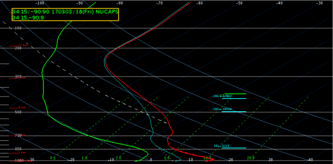
In the Air Mass RGB image above you can see a well-defined upper-level temperature and moisture boundary across the southern U.S. associated with yesterday’ s passing frontal system.  NUCAPS Soundings can provide additional information about the thermodynamic and stability characteristics of the lower-levels of the atmosphere which cannot be deciphered in the Air Mass RGB.  The Sounding at Location 1 shows a mostly dry atmospheric column, which is typical for the orange colored regions (i.e dry upper levels) in the RGB, note however there are moister conditions around 850 mb.    The Soundings at Location 2 and 3 in the green colored regions (i.e. moist upper levels)  confirm moist upper-level conditions.  What the NUCAPS Soundings reveal is a layer of much drier mid-level air between about 850-400 mb, which cannot be detected in the Air Mass RGB.  The ability to detect such a layer can be important in data sparse regions.  Although this is a benign weather situation where much of the Southeast enjoyed sunny, cool, and dry conditions today, this same technique can be applied to more intense, high impact events to assess the thermodynamic environment surrounding a developing low pressure system or weakening hurricane where moist or dry layers can have an impact on storm intensity.

nuprofile1

AWIPS-II CrIS/ATMS NUCAPS Sounding 3 March 2017 1817 UTC at Location 1

nuprofile2

AWIPS-II CrIS/ATMS NUCAPS Sounding 3 March 1817 UTC at Location 2

nuprofile3

AWIPS-II CrIS/ATMS NUCAPS Sounding 3 March 2017 1817 UTC at Location 3


For more information regarding the Air Mass RGB, including applications and interpretation guides for the color features in the imagery:

NUCAPS Soundings and Hurricane Matthew

CrIS/ATMS soundings processed through the NOAA Unique Combine Processing System (NUCAPS) are available in AWIPS.  SPoRT is working with the Joint Polar Satellite System (JPSS) Proving Ground to testbed the utility of NUCAPS soundings to anticipate hurricane tropical to extratropical transition.  Although satellite derived soundings are “smoother” than radiosondes they can provide valuable information about the depth of moist or dry layers in data sparse regions. Forecasters can anticipate extratropical transition by identifying the dry slot and upstream potential vorticity anomalies on satellite imagery that may interact with a storm while also considering many other factors that lead to extratropical transition.  Although Hurricane Matthew is not expected to undergo extratropical transition for quite a few days, the NUCAPS Soundings can be used to diagnose the temperature and moisture characteristics surrounding the hurricane as highlighted below.

GOES-13 water vapor imagery shows dry upper levels west of Hurricane Matthew and abundant moisture surrounding the system (Fig. 1).  Since water vapor imagery can only detect moisture characteristics in the mid-to upper- levels of the atmosphere, the NUCAPS soundings (green dots on Fig. 1) can be analyzed to provide more information about the vertical extent of the dry air and whether it is in close proximity to the hurricane in the mid- to lower- levels.

figure1

Fig. 1. 5 October 2016 1830 UTC GOES-13 water vapor imagery and 1811 UTC NUCAPS Soundings. Green dots represent point and click soundings. Blue numbers label location of example soundings highlighted below.

Scroll down through the example Soundings to compare the changes in moisture conditions west of Hurricane Matthew. Soundings 1 and 2 (Fig. 2 and 3), taken in a region of dry air as identified by the orange color enhancement on the water vapor imagery, confirm a dry column throughout the depth of the atmosphere. Sounding 3 (Fig. 4) shows the drying is not as intense in the upper-levels and mid-level drying extends down to about 600 mb. Sounding 4 and 5 (Fig. 5 and 6) show upper level conditions are more moist closer to the hurricane, as expected from the water vapor imagery. While Sounding 4 (Fig. 5) shows moist conditions throughout the atmospheric column, Sounding 5 (Fig. 6) does show mid-level dry air is present.  Previous analysis of Sandy 2012 and Arthur 2014 showed the same signature (e. g., similar to Sounding 5) became more abundant surrounding the systems as upper-level dry air intruded.  Currently, there are very few soundings with this signature surrounding Hurricane Matthew.  The NUCAPS soundings confirm dry atmospheric conditions are well west of the system and there is very little mid- to low- level dry air in the proximity of the system.  This preliminary example is presented but as Hurricane Matthew continues to evolve NUCAPS Soundings and SPoRT Ozone Products will be analyzed to discern the utility for anticipating dry air intrusion and associated hurricane tropical to extratropical transition.

Sounding 1

figure2

Fig. 2. 5 October 2016 1811 UTC NUCAPS Sounding at Location 1.


Sounding 2

figure3

Fig. 3. 5 October 2016 1811 UTC NUCAPS Sounding at Location 2.

Sounding 3

figure4

Fig. 4. 5 October 2016 1811 UTC NUCAPS Sounding at Location 3.

Sounding 4

figure5

Fig. 5. 5 October 2016 1811 UTC NUCAPS Sounding at Location 4.

Sounding 5

figure6

Fig. 6. 5 October 2016 1811 UTC NUCAPS Sounding at Location 5.


VIIRS Day-Night Band Imagery and Fog Detection

Working midnight shifts this past weekend, I had the opportunity to take a look at the VIIRS Day-Night Band Imagery for the detection and analysis of fog.  Early Monday morning, the observation at Ft. Payne was indicating fog with 1/2 statute mile visibility.  However, the presence of thin cirrus over parts of the area did not allow for the observation of ground phenomena, including fog, in the region via traditional Shortwave IR imagery (Image 1).  However, low clouds and fog were observed in the VIIRS Day-Night Band imagery since the cirrus were sufficiently translucent in the visible portion of the spectrum (Image 2).

ShortWaveIR_22Aug2016_0728Z

Image 1. VIIRS 3.9 µm IR image provided by NASA SPoRT, valid 0728 UTC 22 Aug 2016. Fog cannot be observed in the 3.9 um imagery since the cirrus are sufficiently opaque at this wavelength.

DNBReflectance_22Aug2016_0728Z

Image 2. VIIRS Day-Night Band Reflectance provided by NASA SPoRT, valid 0728 UTC 22 August 2016. Fog can be seen in the narrow Paint Rock Valley of western Jackson County (in northeastern Alabama). Despite the observation of fog at Ft. Payne (DeKalb County AL, –located to the SE of Jackson County), fog cannot be readily observed in the imagery, suggesting that the fog was very localized and perhaps shallow.

I could show the standard fog product imagery (11-3.9 µm), but the story is essentially the same as that of the 3.9 µm imagery of course.  The ability to see through thin cirrus is one of the primary advantages offered by the VIIRS Day-Night Band imagery and thus is among its most useful applications, operationally speaking.  These imagery are a part of the JPSS Proving Ground and have been available in AWIPS here at the HUN office for several years now, including other SPoRT collaborative partners.

In this particular case, it was operationally advantageous to see that the extent of the fog was not widespread and was just confined to some of the more fog-prone valley locations, especially the Paint Rock Valley, and may have only been highly localized to Ft. Payne, or even just the Ft Payne airport observation location.  Had the fog been observed through a larger area in Jackson and especially in DeKalb Counties, then a dense fog advisory might have been necessary.


Observations of NUCAPS Soundings in the TN Valley — 20 July 2016

So, recently I’ve had the opportunity to use and evaluate soundings from the NOAA Unique Combined Atmospheric Processing System (NUCAPS).  These soundings, produced by the ATMS and CrIS instruments onboard the Suomi NPP satellite, are available in AWIPS generally twice per day over any given location.

NUCAPS_exampleswath

Image 1.  NUCAPS Sounding data availability example, ~19 UTC 24 July 2016. Colors represent quality control flags — green are considered best available and most representative data.

A couple of advantages of the NUCAPS soundings is they’re available in relatively high spatial resolution (image 1) and also in between radiosonde launches.  So, a forecaster wanting to know more about tropospheric conditions during the midday or early afternoon (usually the most crucial period for severe weather analysis) can utilize NUCAPS sounding data, since radiosonde data won’t be available until later in the evening (unless ~18 UTC launches are being conducted at their location).  On a number of days in recent weeks, a lack of sufficient boundary layer moisture (probably partly due to an ongoing drought in the region) have dampened convective development.  A good understanding of the degree of convective inhibition (CIN) present on a given day can be difficult to obtain and model analyses and forecasts don’t always seem to have a good handle on this.  Even other robust analyses often struggle with a seemingly accurate depiction of CIN on many days.  However, knowledge of CIN, among other factors, can be important when forecasting probabilities for convective development on summer days.

Recently however, I’ve noticed that NUCAPS soundings did indicate the presence of CIN when convective development was perhaps less than expected or forecast.  July 20th was one of these days.  Take a look at the NAM Bufr Sounding for HSV, valid for 19 UTC on 20 July 2016 (image 2).

NAMBufr_HSV_20July2016_19Z_cropped

Image 2.  NAM Bufr Sounding for KHSV, 19 UTC 20 July 2016

The NAM Bufr model sounding indicated robust CAPE values (generally >2500 J/Kg) and little to no CIN.  Now, let’s take a look at a couple of nearby representative NUCAPS soundings (unfortunately, they don’t include the associated data tables).  Image 3 shows the locations of the NUCAPS soundings with respect to the KHSV observation site and the location in the NAM forecast sounding above (image 2).

SoundingLocations_blog

Image 3.  NUCAPS Sounding locations for image 4…also, the KHSV location in northern Alabama

July202016_NUCAPSSoundings_Blog

Image 4.  NUCAPS Soundings at 19 UTC for location A (left, west of KHSV) and location B (right, southwest of KHSV), 20 July 2016

Even though data tables are not shown from the NUCAPS soundings, notice that they indicate much less instability and less steep lapse rates than the NAM Bufr sounding prognostications for the same time (19 UTC).   Also, notice that LCL levels are below the LFC, indicating some amount of CIN at both locations.  If memory serves correctly, NUCAPS soundings indicated CIN values around 25-50 J/Kg at this time.  So, for a forecaster struggling with the likelihood/coverage of convective development and the strength of convective updrafts, the NUCAPS data would have suggested lesser magnitude for both, over the NAM progs.  Image 5 shows the general dearth of convective activity in the area of northern Alabama near 19 UTC that day.  And indeed, convection was generally limited through the afternoon, with mostly isolated, small cells present.

CompRefl_NUCAPSLocations_20July2016_1856Z

Image 5. Composite reflectivity (dBZ) at 1830 UTC 20 July 2016

When viewing the NUCAPS soundings, I’ve generally been looking for CAPE/CIN values while in the convective season.  Of course, having to click on a number of soundings can be a bit laborious.  As part of a JPSS Proving-Ground/Risk Reduction multi-organization project, researchers at CIMSS, CIRA, GINA and NASA SPoRT have developed gridded NUCAPS data, which were utilized in the Hazardous Weather Testbed this past spring.  I’ll be working with members of the SPoRT team to ingest those data in AWIPS II here at the HUN office in the near future for my own testing, evaluation and feedback to the NUCAPS group within the JPSS Proving Ground.  I’m looking forward to the future use and evaluation of these potentially useful operational data sets.