So, when are total lightning data useful? Well, there are many such cases, and we’ve described many of those in this blog…including my post yesterday. But, they’re also particularly useful when the National Lightning Detection Network (NLDN) data drop out of AWIPS. That is what happened earlier this evening, in an apparent system-wide outage that lasted for a couple of hours. When you’re in operations, data redundancies are great to have, particularly for these types of cases.
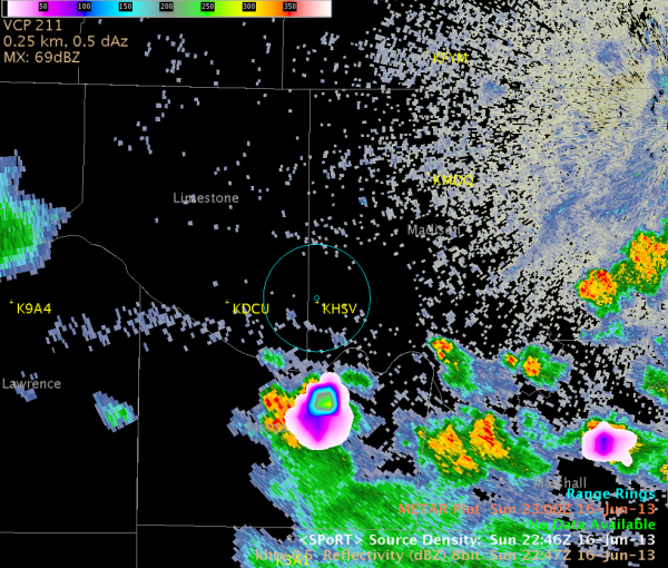
At about 2247 UTC, a thunderstorm was moving across northern portions of Morgan County, AL, and was approaching southern Madison County (image 1). Initially, the thunderstorm was expected to remain to the south and east of the Huntsville International Airport, for which we provide Airport Weather Warnings.

Image 1. KHTX radar reflectivity (dBZ, 2247 UTC), overlaid with North Alabama LMA source densities (2246 UTC). The location of the Huntsville airport (KHSV) and a 5-mile radius ring (blue circle) from the KHSV location are also included.
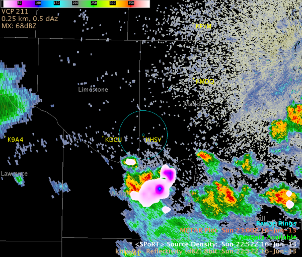
However, by 2252 UTC, a small shower had developed along outflow to the northwest of the thunderstorm, and had just become electrically active (image 2). Notice the (albeit small) LMA source density values just to the southwest of the airport radius ring at this time. Of course, due to the NLDN data outage, we had no idea if the thunderstorm was producing CG strikes, but the total lightning data was sufficient for letting us know that the cell had become electrically active.

Image 2. KHTX radar reflectivity (dBZ, 2252 UTC ), overlaid with North Alabama LMA source densities (2252 UTC). The location of the Huntsville airport (KHSV) and a 5-mile radius ring (blue circle) from the KHSV location are also included.
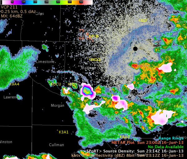
Armed with this new information, the forecaster issued an Airport Weather Warning for the Huntsville Airport at 2252 UTC. The next image (image 3) shows that the LMA indicated lightning (at least intra-cloud) within the 5-mile radius ring at 2314 UTC.

Image 3. KHTX radar reflectivity (dBZ, 2312 UTC), overlaid with North Alabama LMA source densities (2314 UTC). The location of the Huntsville airport (KHSV) and a 5-mile radius ring (blue circle) from the KHSV location are also included.
Knowing that intra-cloud flashes often precede CG strikes, and that thunderstorms in this type of environment will often eventually produce CG flashes, the total lightning data are invaluable, and can help to buy extra minutes of lead time in a rapidly evolving situation. In this case however, we also see the added benefit when other data are simply unavailable.

Another great post by the LMA experts. Great job Huntsville WFO!