As mentioned in the previous post, we were concerned about the potential of organized thunderstorm outflow creating favorable conditions for blowing dust, as well as previous heavy rain activity increasing the potential for flash flooding in portions of Southeast Arizona yesterday (Sep 2) and today. We have been trying to use LIS data as part of our process in determining the threat of both of these problems. Yesterday was a mixed bag as I briefly outline below with less than full cooperation from the atmosphere.
Convective initiation occurred in locations we expected (similar to the WRF output posted previously), however we were unable to get the chain reaction of outflows that we hoped for. We had problems in many valley locations (especially the Tucson Metro area) with early debris cloud and then anvils from early convection blocking solar insolation. We also underestimated the eastern extent of a modest low level drying trend filtering in from western Pima county.
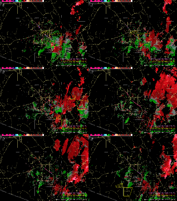
Below is a loop of velocities with some observation and warning overlays early yesterday afternoon. The initial 45 kt outflow from the SVR southeast of Tucson attenuated rapidly as it approached Tucson. Readings from Davis-Monthan AFB on the southeast side of Tucson at 2137Z showed a gust out of the SE at 30kts, and shortly later Tucson International Airport (a couple of miles further west) registered 23 kts. By the time the outflow was west of Tucson it was difficult to detect. There was no additional activity along this outflow in Pima County and it certainly wasn’t strong enough on it’s own to generate any dust problems by the time it got to areas we were concerned about. The initial area that it started southeast of Tucson does have dust issues at times, but referring back to the soil moisture imagery from the previous post, things were pretty wet there.
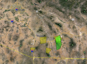
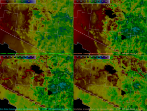
It was an active day however. Below is a composite post of the Severe Thunderstorm (yellow) and Flash Flood (green) products we issued yesterday. When you compare to the 09z LIS output posted yesterday, the Flash Flood warnings were issued in an area with relative soil moistures above 70 percent (posted again for convenience).
We once again have a favorable atmospheric profile for strong storms today (Sep 3), but with a little more convective inhibition to overcome and continuing issues with cloud cover. We do have a stronger impulse embedded in the southwesterly flow that will push into our area late today and this evening. Most standard and mesoscale model output (including latest UofA WRF and national HRRR) show increased coverage and organization of thunderstorm activity by late afternoon, especially west of Tucson. This seems very reasonable, keeping the aforementioned caveats in mind.
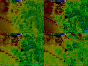
A look at today’s LIS output shows that soil conditions are even more favorable in the areas of concern west and northwest of Tucson. Especially in eastern Pinal and Maricopa counties with widespread values below 15 percent:
Some of the special communications to our partners and the general public yesterday morning extended into mentions of issues for today as well. We will adjust our weather story and social media posts to reflect the latest information, but our message is similar to yesterday. We will again coordinate with Phoenix about any possible coordinated dust headline later this morning. An example of the partner email we sent yesterday below:


A brief update on Sep 3. Some nice results with strong outflows originating in our area and pushing into our targeted areas of concern in Pinal and Maricopa counties, (primarily in Phoenix’s area). It looks like areas that were at or below 15 percent relative soil moistures reacted well to the organized outflows from Pima and our portion of Pinal county. In addition we followed the busy previous day with more flash flood warning and flood advisory products. I would like to follow up with a more detailed post about the 2 days from both a dust and heavy rain perspective, but for now here are a few links to twitter posts from news media: https://twitter.com/DrMatt12News/status/639566083804954624/photo/1 … https://twitter.com/CBS5AZ/status/639552996750131201/photo/1 … https://twitter.com/CaribeDevine/status/639553267093999616/photo/1 … https://twitter.com/12NewsNico/status/639551400876224513/photo/1
Thanks for the post, Jim. It’s great to see your engagement in using the LIS data for dust and flooding applications in SE Arizona! Examining LIS for soil moisture thresholds correlating with blowing dust episodes shows great promise! I do want to offer caution in applying LIS soil moisture thresholds for *flash* flooding situations. Granted, localized very moist soils can give forecasters a heightened sense of awareness to areas more prone to flash flooding. However, I’m sure you know well that intense convective rain rates can lead to high runoff and flash flooding, regardless of the antecedent soil conditions. In that light, I’d be very interested to see how the NWS flash flood guidance is currently applied in these situations, and how the LIS soil moisture distribution can help enhance forecasters assessment of areas most prone to flash flooding. Thanks again for the great post!